Chandrayaan-2 Maps Water Ice and Lunar Soil at Moon’s Poles
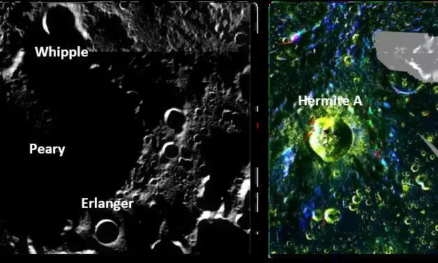
New Delhi, November 9, 2025 India’s Chandrayaan-2 mission has once again delivered groundbreaking insights, this time revealing detailed radar images of water ice and soil on the Moon’s polar regions. Operating since 2019, the Chandrayaan-2 Orbiter has collected and analyzed nearly 1,400 radar datasets over the past five years, covering latitudes from 80 to 90 degrees in both the northern and southern hemispheres. Scientists at ISRO’s Space Applications Centre (SAC) in Ahmedabad used data from the Dual Frequency Synthetic Aperture Radar (DFSAR) instrument to produce the first full-polarimetric, high-resolution radar maps of the Moon. With a spatial resolution of 25 meters per pixel, these maps allow researchers to study both surface and subsurface characteristics with remarkable precision. The DFSAR instrument works in multiple modes, transmitting and receiving both vertically and horizontally polarized radar signals. This capability lets scientists detect key features such as water-ice deposits, surface roughness, and soil density and porosity. By analyzing these properties, the team can better understand the Moon’s surface composition and hidden geological structures. A critical indicator used in the study is the Circular Polarisation Ratio (CPR), which is sensitive to reflections from subsurface ice. Other parameters, such as the Single Bounce Eigenvalue Relative Difference (SERD) and the T-Ratio, help measure surface roughness and dielectric properties of the lunar soil. Polarimetric decomposition components—Odd, Even, Volume, and Helix—further clarify different radar scattering processes across the Moon’s terrains. The Level-3C polar mosaic datasets generated from DFSAR data are now publicly available to the scientific community. These results are expected to play a crucial role in planning future lunar missions, particularly in identifying stable thermal zones where water ice could exist and selecting safe and resource-rich landing sites. Beyond practical applications, the findings offer deeper scientific knowledge about the Moon’s untouched polar regions. These areas may contain some of the earliest preserved chemical signatures of the solar system, offering a window into its formative years. The combination of radar and hyperspectral data from Chandrayaan-2 is also expected to improve global models of lunar mineral distribution. By providing precise maps of water-ice deposits and surface characteristics, the mission strengthens India’s position in lunar exploration and paves the way for future missions focused on sustainable lunar research and potential resource utilization. This latest achievement highlights Chandrayaan-2’s ongoing contributions to space science, demonstrating how long-term data collection and advanced processing techniques can reveal previously hidden aspects of the Moon. Chandrayaan-2 Reveals Water Ice and Soil Details at Moon’s Poles India’s Chandrayaan-2 mission has given scientists an exciting new look at the Moon’s polar regions. The orbiter, which has been circling the Moon since 2019, collected nearly 1,400 radar datasets over the past five years. Using this data, ISRO scientists created detailed maps showing water ice, soil types, and hidden geological features near the Moon’s north and south poles. The mission used the Dual Frequency Synthetic Aperture Radar (DFSAR) to scan the surface and below. This radar can detect reflections from ice, measure how rough the surface is, and study soil density and porosity. One key measurement, the Circular Polarisation Ratio, helps spot ice below the surface, while other radar signals give insight into the soil and terrain types. These new maps are now available for scientists worldwide. They will help plan future lunar missions, especially in choosing landing sites and locating areas where water ice might exist. Understanding the Moon’s polar regions also teaches us about the early solar system, as these areas preserve some of its oldest chemical traces. Chandrayaan-2’s combination of radar and other sensors is helping create the most accurate picture yet of the Moon. These findings are important not just for exploration, but also for future missions aiming to use lunar resources.